
What Is in a Name? Ontario
Updated: Sep 17
On August 27, 2026, President Donald Trump signed an executive order directing United States federal agencies to call Lake Ontario “Lake America.” An executive order can change the wording used by federal agencies and maps. It cannot change the history of the lake or the origin of its name.
Ontario is not a modern Canadian invention. It is a Native name, rooted in the Indigenous languages and cultures of the Great Lakes. Europeans were recording versions of the name by 1641, more than a century before the United States declared independence and more than two centuries before Canadian Confederation. Understanding that history begins with the water itself.
A government may direct its agencies to print a different label. It cannot make the 1641 record disappear. It cannot separate the lake from the Native languages that named it, nor can it erase the nations whose relationships with these waters continue.
Ontario, A Lake Formed by Ice
Lake Ontario is the easternmost of the five Great Lakes. Its basin was shaped by the Laurentide Ice Sheet, which covered much of northern North America during the last Ice Age.
As the ice retreated, meltwater filled deep depressions carved and reshaped by glaciers. The Great Lakes did not appear all at once in their present form. Their shorelines, depths and outlets changed as the ice withdrew and the land slowly rebounded from the tremendous weight of the glaciers.
Lake Ontario became the final lake in a vast connected system. Water travels from Lake Superior through Lakes Michigan and Huron, Lake St. Clair and Lake Erie. It then passes through the Niagara River and Niagara Falls into Lake Ontario before continuing through the St. Lawrence River to the Atlantic Ocean.
This geography made the lake part of an ancient transportation and trading network. Long before international borders divided the region, Native nations travelled its waters, lived along its shores and understood its place within the larger system of rivers and lakes.
Ontario Is a Native Name
Let's explain: long before modern borders divided these waters, Indigenous peoples knew and named the Great Lakes in their own languages. There was never one universal Indigenous naming system for all five lakes. Names differed among Nations, languages, communities and periods. The precise spelling and translation vary because Europeans attempted to write Indigenous words using French and English spelling conventions. Indigenous languages also changed across communities, dialects and generations.
The name is commonly connected to the Wendat, also known as the Huron-Wyandot, word Ontarí:io (or Ontare). It has been translated as “great lake” or “beautiful lake.” Other explanations connect it with related Iroquoian words such as kanadario or skanadario, translated as “sparkling water” or “beautiful water.”
These interpretations are not identical, but they agree on the most important point: Ontario is an Indigenous name from the Iroquoian language world. The name was not created by the Province of Ontario. The province inherited its name from the lake when it entered Canadian Confederation in 1867. The lake had carried a Native-derived name for centuries before the modern province existed.
Respectfully, we can speak these names. Just as importantly, we can identify the Nation and language connected with each one and acknowledge where the surviving historical record remains uncertain. More names and explanations:

Recorded in 1641, Not Created in 1641
One of the earliest surviving European documents to use the name is the Jesuit Relation for 1640 and 1641. The report was written by the French Jesuit missionary Jérôme Lalemant at Sainte-Marie among the Hurons and dated May 19, 1641. While describing the Great Lakes and the Niagara River, which the document rendered as “Onguiaahra,” Lalemant wrote that the river emptied “into the Ontario or lake of saint Louys.”
This sentence is important because it shows that Europeans were already using “Ontario” as the name of the lake in 1641. The document did not invent the name. It recorded a name that Europeans encountered in an Indigenous world.
The Jesuit Relations must also be read critically. They were colonial missionary reports written from European religious and political perspectives. Their descriptions of Native peoples frequently reflected the assumptions and prejudices of their authors. Nevertheless, the appearance of “Ontario” in the record preserves evidence that the Native name was already in circulation. The surviving document therefore marks an early European recording of the name, not its Indigenous beginning.
A Name That Survived Colonial Renaming
French colonists also applied European names to the lake. During the seventeenth century it was sometimes called Lac Saint-Louis, or Lake St. Louis. It was later called Lac Frontenac in honour of Louis de Buade de Frontenac, governor general of New France.
Those colonial names did not endure.
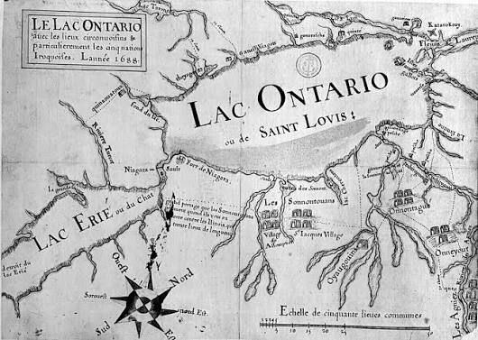
A 1660 map by François Du Creux identified the lake in Latin as Lacus Ontarius. Another French map from the period called it Lac Ontario ou des Iroquois, meaning “Lake Ontario or Lake of the Iroquois.”
These maps show European cartographers gradually incorporating an Indigenous name into their own geographical records. Spellings changed, and competing colonial names appeared, but Ontario survived.
That survival matters. Indigenous place names are often among the oldest historical records still spoken in everyday life. They carry evidence of languages, relationships and systems of knowledge that existed before colonial borders and governments.

Whose Homelands?
The lands surrounding Lake Ontario cannot be reduced to the history of a single people or a single moment. They form part of the homelands, travel routes and treaty territories of several Native nations.
The Indigenous history of the region includes the Huron-Wendat, the Haudenosaunee, the people whom the Wendat called the Attiwandaronk and the French called the Neutral Nation, and Anishinaabe peoples, including the Mississaugas.
Communities moved, formed alliances, fought wars, negotiated treaties and responded to epidemics and colonial expansion. Their histories overlap without becoming interchangeable.
For that reason, the question should not only be, “Whose lands were these?” That wording can place Native peoples entirely in the past. A more honest question is, “Whose homelands do these remain?”
The nations connected to Lake Ontario are not vanished peoples. Their communities, governments, languages and relationships with the water continue.

Why the Name Matters
The Museum of Indigenous People exists “to instill understanding and respect for the Indigenous cultures of the Southwest.” Although Lake Ontario lies outside the Southwest, the principle of integrity remains the same: Native histories should be represented accurately, and Indigenous people should not be treated as if they belong only to the past.
Ontario is not simply a Canadian political label. It is a surviving Native name.
Replacing it with “Lake America” does more than substitute one set of words for another. It removes an Indigenous-derived name and replaces it with the language of a modern nation-state. It places a contemporary political identity over a much older cultural and geographical history.
A government may direct its agencies to print a different label. It cannot make the 1641 record disappear. It cannot separate the lake from the Native languages that named it, nor can it erase the nations whose relationships with these waters continue.
Ontario remains more than a word on a map. It is an Indigenous name carried across centuries, one that describes the water while preserving a trace of the people who knew it long before either Canada or the United States existed.
c
Sources
The Jesuit Relations and Allied Documents, Volume XXI https://moses.creighton.edu/kripke/jesuitrelations/relations_21.html
Government of Canada: Origin of the Names of Canada and Its Provinces and Territories https://natural-resources.canada.ca/maps-tools-publications/maps/geographical-names-canada/origin-names-canada-its-provinces-territories
McCord Stewart Museum: Tabula Novae Franciae, Anno 1660 https://collections.musee-mccord-stewart.ca/en/objects/449811/tabula-novae-franciae
Bibliothèque nationale de France: Map of Lake Ontario or Lake of the Iroquois, 1660–1669 https://heritage.bnf.fr/france-ameriques/carte-dune-partie-nouvelle-france-comprenant-lac-ontario-ou-iroquois-1660-1669
Parks Canada: Geology of the Lake Ontario Region https://parks.canada.ca/pn-np/on/rouge/nature/environnement-environment/geo
Mississaugas of the Credit First Nation: Treaty Lands and Territory https://mncfn.ca/about-mncfn/treaty-lands-and-territory/
White House: Executive Order Concerning Lake Ontario https://www.whitehouse.gov/presidential-actions/2026/08/honoring-the-american-history-of-the-great-lakes-and-renaming-lake-ontario-as-lake-america-3a36/
USA Today: Ontario Name Origin Amid Trump’s “Lake America” Order https://www.usatoday.com/story/news/politics/2026/08/27/ontario-name-origin-amid-trump-lake-america-order/91496090007/
Parks Canada: Bead Hill National Historic Site of Canada https://www.pc.gc.ca/apps/dfhd/page_nhs_eng.aspx?id=531
Canadian Register of Historic Places: Bead Hill National Historic Site of Canada https://www.historicplaces.ca/en/rep-reg/place-lieu.aspx?id=16783
Bead Hill https://en.wikipedia.org/wiki/Bead_Hill
History of the Altona Forest Area https://altonaforest.org/history.html
Active History: Listening to History: Correcting the Toronto Métis Land Acknowledgement, by Jesse Thistle https://activehistory.ca/blog/2019/11/26/tenth-anniversary-repost-listening-to-history-correcting-the-toronto-metis-land-acknowledgement/


